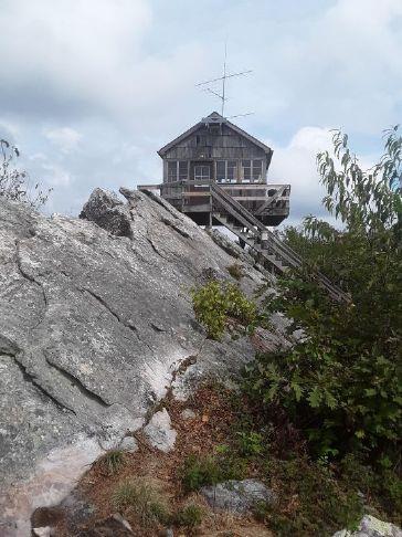
Hanging Rock Raptor Observatory was once a fire watchtower in Monroe County with a 360-degree view of mountain peaks as far away as Virginia.
Resting atop slabs of stone on Peters Mountain 3,812 feet above sea level, the cabin-like observatory seems to float among the clouds and often above the birds many watchers come to spy upon.
The original fire tower was built in the 1930s. A larger structure replaced the first one in 1956 and was used into the 1970s when fire towers ceased operations.
As part of George Washington and Thomas Jefferson National Forests, the United States Department of Agriculture Forest Service acquired the tower in the 90s and renovated the deck.
Someone set fire to the building in February 1996. Public outcry over the tower’s destruction prompted the USDA to rebuild, completing the current structure by May 1997. The forest service maintains the site with the help of Boy Scout troops and volunteers. In 2017 scouts and volunteers replaced damaged plastic windows, and in 2018, volunteers replaced the decking utilizing West Virginia Scenic Trails Association (WVSTA) funds.
“The trail to the tower is part of the Allegheny Trail, a 330-mile hiking trail from the Mason-Dixon line in northern West Virginia to a connection with Appalachian Trail in Virginia about 9.5 miles south of the tower,” according to WVSTA, that utilizes volunteers to maintain the site.
Many of the volunteers, like Charlie Kahle, are on hand to share information on all things Hanging Rock including history, names and approximate distances to visible mountain peaks, locations of nearby towns, migratory bird habits, why a plastic owl named Vernon is staked out on a ridge, and anecdotes such as the tale about the portable toilet known as “Betty’s Loo.”
Kahle told The West Virginia Daily News that late summer into late fall/early winter offers prime bird watching opportunities. Incoming weather fronts pushing winds against the ridges also provide extra lift that bring raptors closer to the tower, Kahle explained.
Observatory visitors are encouraged to log raptor sightings on various lists hanging on the tower walls along with birds above the windows and a life-sized eagle painted across the ceiling by one of the volunteers.
To capture creatures in flight during times where there are no humans around, biologists with the West Virginia Division of Natural Resources (WVDNR) recently installed a radio telemetry station at the observatory to study the movement of birds, butterflies and other migratory animal species.
According to the WVDNR, “The station is part of an international animal tracking network, called Motus, which means movement in Latin. The new station will help WVDNR biologists collect and share data that will be used to build a picture of where migratory animals are traveling.”
“Our goal is to determine the spatial and migratory patterns of species of greatest conservation need that we track in our state wildlife action plan,” said Mack Frantz, a zoologist for the WVDNR.
Kahle pointed out the antenna and solar panel for the radio telemetry technology that was installed on the tower. This system detects the movement of radio-tagged animals 10 or more miles away and local movements closer than a mile.
“Each tag sends out a unique individually identifiable pulse that can be interpreted by a computer, which means individual animals can be detected with precision,” explains a WVDNR press release.
“The antennas we installed can track a lot of cool things, such as movement patterns and where an animal is flying and how fast,” Frantz said. ” We can know, down to the second, when a roosting bird decides to wake up and take flight.”
The press release explains further, “With the data collected at Hanging Rock and at hundreds of other stations in the Motus network, WVDNR biologists are hoping they can help determine local and regional movements of rare, threatened and sensitive species and see which habitats and landscapes are important for their survival.”
“What biologists learn,” Frantz said, “will also be used to aid collaborative conservation efforts of federal, state and other non-government agencies.”
Counting migrating raptors passing above, beside and below Hanging Rock began in the early part of the 20th century, “even before the first fire tower was built on the spot. The counts include the species, time of day, temperature, wind and sky conditions. Some count data is posted at the tower,” according to details provided by the observatory. Data is also shared with the national hawk count database.
The timing of bird migration around the fall season makes viewing even more beautiful with the changing of the leaves. Cooler temperatures also make the climb to the tower more pleasant. The expansive view from the tower is perfect as a backdrop for proposals, weddings, family portraits and other events worth photographing. Sunrises and sunsets are spectacular. Shimmering ice and sparkling snow can be breathtaking from above.
The tower offers a spectacular view, but possible sightings of bald eagles, golden eagles, broad-winged hawks, kiting red-tailed hawks, sharp-shinned hawks and many other migratory birds and butterflies add a bonus that makes the hike up to the tower worthwhile, for it is a sometimes steep, often rocky climb.
No matter the season or the reason, Hanging Rock advises to “Be sure to take drinking water. Other things you should consider are comfortable hiking shoes, hat, sunglasses, binoculars and an extra layer of clothing. It is usually 8-10 degrees cooler on top. The hike from the parking lot is a little less than a mile with a rise of 350 feet and will take anywhere from 25 to 50 minutes depending on your enthusiasm. The trail is well marked with yellow blazes. The side trail to the tower is blazed in blue. To avoid [a] steep section … and a rocky area near the tower, you can proceed farther along the Allegheny Trail and access the blue trail from the other end. This takes you past the outhouse and back to the tower and only adds about 500 feet to the hike.”
Directions to Hanging Rock Raptor Observatory:
From Waiteville, WV, take Limestone Hill Road (Co. Rt. 15) 4 miles. On the left you’ll see a sign for Hanging Rock. Take the left into the gravel parking lot.
From Gap Mills, WV, take Zenith Road and proceed 3.5 miles to Limestone Hill Road. Proceed 1.8 miles after you turn left onto Limestone Hill Road to a parking area above the road on your right, but you have to watch for it; it is easy to miss. It is a small gravel area that will hold 8 or 10 cars at most. If you start going downhill you have missed it.
In November 2010 the forest service erected new signs at the parking lot. The tower is a hike of .9 miles from the lot. The hike from the upper lot is a little longer but somewhat flatter on the lower half. The trail entrance from this lot is marked with yellow paint, which signifies the Allegheny Trail.
From Paint Bank, VA, turn off of route 311 onto CR 600 and proceed 11 miles to Waiteville, WV. Turn right onto Limestone Hill Road (CR 15 ) and go 4 miles. On the left you’ll see a sign for Hanging Rock. Take the left into the gravel parking lot.
From Rock Camp, WV, turn onto Willow Bend Road. After 2.5 miles or so, watch for a turnoff back to the right for Zenith Road. Proceed about 8 miles and turn right onto Limestone Hill road. 1.4 miles after you turn left onto Limestone Hill Road, there will be a hairpin turn to the left. You will notice it has been widened to accommodate parking along the road. Your best bet is to proceed another 0.4 miles until you top the hill. At this point, there will be a parking area above the road on your right, but you have to watch for it; it is easy to miss. It is a small gravel area that will hold 8 or 10 cars at most. If you start going downhill you have missed it.
In November 2010 the forest service erected new signs at the parking lot. The tower is a hike of a little less than 3/4 mile from the lower parking area and between .8 and .9 miles from the upper lot. The hike from the upper lot is a little longer but somewhat flatter on the lower half. The trail entrance from this lot is marked with yellow paint, which signifies the Allegheny Trail.
Some web mapping platforms and GPS systems may show a right-hand turn onto Firetower Road, this is not correct, simply continue along Limestone Hill Road and go to the top of the mountain. The parking lot is on the right.The path leading to the tower is part of the 320-mile Allegheny Trail for foot traffic from the W. Va. – Pennsylvania border in Preston County to Monroe County’s border with Virginia. Adventure seekers looking to expand their horizons should consider visiting more of the Allegheny Trail.
“In addition to the popular state park and forest trails, a hiker can encounter (north to south) Cheat Canyon, Blackwater Canyon Rail Trail, West Fork Rail Trail, High Falls of Cheat Trail, Gaudineer Scenic Area, Greenbrier River Rail Trail and Hanging Rock Raptor Observatory,” notes WVSTA. Visit www.wvscenictrails.org for more information or to receive a hiking guide.
To learn more about the West Virginia Division of Natural Resource’s State Wildlife Action Plan, visit wvdnr.gov/Wildlife/Action_Plan.shtm.